Reading the live feed from Caltrans...

Reading the live feed from Caltrans...
The corridor's high country: Conway Summit at 8,138 feet, Mono Lake, Lee Vining, the June Lake junctions, and Deadman Summit.
Conway Summit and Lee Vining is open. No chain controls are in effect on this stretch right now.
Jct. 270 / Bodie Rd. · Bridgeport · 6,870 ft
No chain controls are in effect at this time.
Bodie Flats / 8 Mi. S of Bridgeport · Bridgeport · 7,316 ft
No chain controls are in effect at this time.
11 Mi. S of Bridgeport / 1 Mi. N of Conway Summit · Lee Vining · 7,900 ft
No chain controls are in effect at this time.
10 Mi. N of Lee Vining / 16 Mi. S of Bridgeport · Lee Vining · 7,463 ft
No chain controls are in effect at this time.
Foot of Conway / 8 Mi. N of Lee Vining · Lee Vining · 6,971 ft
No chain controls are in effect at this time.
Jct. 167 / Pole Line Rd. · Lee Vining · 6,906 ft
No chain controls are in effect at this time.
Mono Lake / 2 Mi. N of Lee Vining · Lee Vining · 6,522 ft
No chain controls are in effect at this time.
Lee Vining / JNO High School · Lee Vining · 6,748 ft
No chain controls are in effect at this time.
Lee Vining City Limits · Lee Vining · 6,814 ft
No chain controls are in effect at this time.
7 Mi. S of Lee Vining · June Lake · 7,066 ft
No chain controls are in effect at this time.
Sand House / 8 Mi. S of Lee Vining · June Lake · 7,329 ft
No chain controls are in effect at this time.
S Jct. 158 · June Lake · 7,696 ft
No chain controls are in effect at this time.
S Jct. 158 · June Lake · 7,719 ft
No chain controls are in effect at this time.
Hartly Springs / 2 Mi. S of S Jct. 158 · June Lake · 7,910 ft
No chain controls are in effect at this time.
Crestview MTCE Stn. / 6 Mi. S of S Jct. 158 · Mammoth Lakes · 7,513 ft
No chain controls are in effect at this time.
Crestview MTCE Stn. / 8 Mi. N of Jct. 203 · Mammoth Lakes · 7,519 ft
No chain controls are in effect at this time.
Scenic Loop Rd. / 4.5 Mi. N of Jct. 203 · Mammoth Lakes · 7,572 ft
No chain controls are in effect at this time.
Scenic Loop Rc. / 4.5 Mi. N of Jct. 203 · Mammoth Lakes · 7,578 ft
No chain controls are in effect at this time.
S End of Trees / 1 Mi. N of 203 · Mammoth Lakes · 7,319 ft
No chain controls are in effect at this time.
Jct. 203 / Mammoth Off-Ramp · Mammoth Lakes · 7,290 ft
No chain controls are in effect at this time.
Sherwin Crk. Rd. / 1 Mi. S of Jct. 203 · Mammoth Lakes · 7,188 ft
No chain controls are in effect at this time.
Every Caltrans chain checkpoint on this stretch, in the order you will meet them. The level is read from Caltrans's own posting for that checkpoint. What R-1, R-2, and R-3 require is on the chain guide.
US 395 NB Lee Vining
SR 120 - CLOSED\\
SR 108 - CLOSED\\
SR 89 - CLOSED
Lane Closure
2 of 4 lanes closed at Virginia Lakes Road, northbound, for drainage work.
Lane Closure
Traffic Break at Virginia Lakes Road, southbound, for utility work.
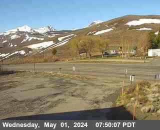
Lee Vining · 8,149 ft · Caltrans still image
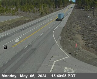
June Lake · 8,031 ft · Caltrans still image
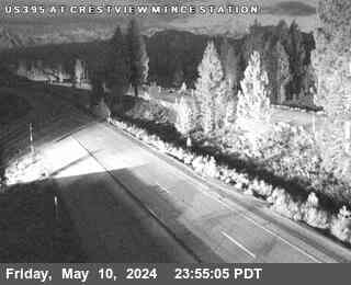
Mammoth Lakes · 7,529 ft · Caltrans still image
Conway Summit
Now: Mostly Sunny, 49°F, wind 5 to 10 mph S.
Tonight: Partly Cloudy, 28°F.
Forecasts: National Weather Service, for each point itself.
This is the stretch drivers mean when they ask about US-395. South of Bridgeport the highway climbs to Conway Summit at 8,138 feet, drops to Lee Vining and Mono Lake, passes both June Lake Loop junctions, and crosses Deadman Summit at 8,036 feet before reaching the Mammoth Lakes turnoff. It collects the corridor's chain controls first and gives them up last, and its two summits can be in different weather an hour apart.
Conway Summit is the high point of this drive and one of the highest points on US-395 anywhere. Weather at the summit can be a different season from Bridgeport below it. The summit overlook above Mono Lake is one of the great roadside views in California, and the grade on both sides is exposed to the full force of Sierra storms. Conway is usually the first place on the corridor to see chain controls and the last to lose them. Check the Conway Summit camera on this page before you climb.
The descent from Conway winds down to Lee Vining on the west shore of Mono Lake, where SR-120 turns west toward Tioga Pass and Yosemite in the summer season. Lee Vining has fuel, food, and lodging, and it is the natural regrouping point before the next climb. South of town, the two junctions of SR-158 bracket the June Lake Loop; the loop's own conditions belong to the June Lake roads, and this page carries the junctions as status lines only.
South of the June Lake junctions the highway crosses Deadman Summit at 8,036 feet, a wooded, deceptively gentle pass that ices early and holds snow late, before dropping to Crestview. Just south of there, SR-203 turns west to Mammoth Lakes and Mammoth Mountain. On storm weekends this junction is the corridor's pressure point: ski traffic, chain controls on Deadman, and valley traffic all arrive at the same few miles of road. This page covers the drive to the turnoff; the road into Mammoth Lakes is SR-203's own story.
Right now, conway Summit is open with no chain controls posted (Caltrans).
Is Conway Summit open?
Check the live status at the top of this page, with its Caltrans timestamp. This page is the Conway Summit stretch itself, from Bridgeport to the Mammoth Lakes turnoff, so its verdict is the Conway Summit verdict.
Do I need chains on Conway Summit today?
Check the live checkpoint list on this page. Conway Summit and Deadman Summit both collect chain controls in Sierra storms, and controls can be up on one while the other is bare pavement. The list shows the level for your exact part of the stretch.
Is the road to Mammoth Lakes open?
Check the live status at the top of this page. It covers US-395 to the SR-203 turnoff. The last miles into Mammoth Lakes are on SR-203, which has its own postings at the junction.
What does the Conway Summit camera show?
The camera on this page sits at the summit itself, about 8,149 feet. Look at the live image to see whether snow and wet pavement are reaching the top of the grade before you start the climb from either side.
Road, weather, and camera data: Caltrans District 9, the California Department of Transportation's Eastern Sierra district.